Locating MH-370 from the Sky
The clever way satellite data was used to try and help locate the missing plane
In a previous piece, we explored what happened to Malaysian Air flight 370 in the time leading up to its disappearance during a trip from Kuala Lumpur to Beijing a decade ago. The missing aircraft, a Boeing 777, is a massive airplane, so it truly confounded the public as to how it could have simply vanished.
People questioned whether commercial aircraft are tracked along their entire flight. This incident taught them that the answer to this is, in many cases, no. That someone onboard disabled the usual methods for tracking such flights all but ensured its ability to disappear.
At 01:19:29 that fateful night, March 8, 2014, the captain of the aircraft, Zaharie Ahmad Shah, spoke the last words anyone would ever hear from him or the aircraft: “Good Night, Malaysian Three Seven Zero.” Then, it dematerialized from civilian radar and, within a short time after, from the world generally.
Or did it?
What follows details how experts managed to trace the possible route of the aircraft after it ‘went dark.’ As many undoubtedly know, search efforts that originally targeted the flight’s anticipated path eventually shifted considerably westward. That is, instead of scouring the South China Sea, they suddenly spent massive amounts of resources and time on the southern Indian Ocean. What led them there was something called INMARSAT satellite data.
Before we dive into this topic you may want to read the first piece on MH-370, if you have not already, that lays out the full timeline of the flight from when the pilots first arrived at the airport until its last blip on military radar.
Note that below, page number hyperlinks indicate the pages in the final report: The Malaysian ICAO Annex 13 Safety Investigation Team Report for MH370. Other referenced documents will include the author’s name with the page number (when relevant).
Finally, at the risk of frightening away some readers, I need to warn you that this article contemplates highly technical information. I make a strenuous effort to explain it as clearly as possible.
INMARSAT
The company INMARSAT describes itself as follows:
Today, we have the world’s most advanced and resilient mobile connectivity infrastructure to ensure that our satellite services are not only saving lives but also providing a connectivity lifeline in the most remote and challenging locations.
We serve aviation, maritime, government and enterprise markets with an unparalleled portfolio of services and solutions. Our customers range from airlines and shipping fleet operators to the military and aid agencies, and a host of commercial enterprises, from mining and logistics to agriculture. What they all share in common is the need for highly reliable connectivity, no matter where they are.
The official report, pp. 115-116, explained in detail how the INMARSAT system works:
The Inmarsat system utilises a constellation of satellites to provide nearly global coverage, the exception being polar areas. The aircraft SATCOM system, also referred to as an Airborne Earth Station (AES) operates on L Band, transmits at 1.6 GHz and receives at 1.5 GHz. For this aircraft, the SAFETY INVESTIGATION REPORT MH370 (9M-MRO) 116 SATCOM system provided a total of five voice channels and one data channel. The satellite link provides the following functions:
Audio and text communication;
ACARS data; and
In-flight Entertainment (IFE) Equipment connectivity.
The Earth or Ground Station uses C Band, transmits at 6 GHz and receives at 4 GHz. Inmarsat uses a network of Ground Earth Stations (GES) to communicate with the satellites and connect the SATCOM signal to other terrestrial data networks such as telephone systems, internet, etc.
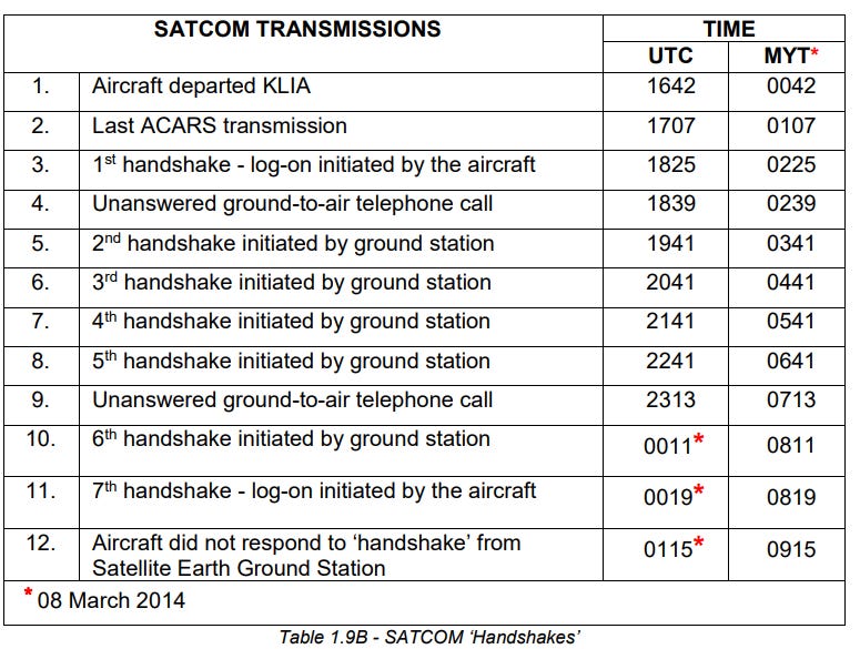
The onboard INMARSAT system sends a log-on request whenever it is switched from a power-off to a power-on state. Additionally, the system sends a regular notice to the ground earth stations (GES) during the time it is powered on. If it fails to do so after one hour, the GES will automatically send a ping request to the INMARSAT onboard system. If the onboard system receives it, it will reply with an affirmative message that it remains logged on. INMARSAT calls these connections ‘handshakes’ (pp. 115 - 118). These handshakes proved to be critical data in tracing the path of the airliner after it departed from the last radar coverage area, which belonged to the military.
The timeline of INMARSAT data
MH-370 lifted off the runway from Kuala Lumpur at 00:42 (all times are given in Malaysian time). The first INMARSAT status report transmitted twenty-five minutes later at 01:07. On MH370, the system was set to routinely send this status report every thirty minutes. Over the next two thirty-minute windows, the system sent no report or other transmission. This is notable because Captain Zaharie’s final radio contact, at 01:19, occurred just twelve minutes after the first INMARSAT status report transmission. Only a few minutes after that, MH370’s transponder code and radar signatures were lost.
At 02:25, the INMARSAT ground station received a log-on request from MH370, suggesting that from sometime between 01:07 and 02:25, the onboard unit was powered off. Given the timing of the loss of the transponder signal, this seems purposeful. From 02:25, the unit remained powered-on for about the next six hours, though it only pinged and did not send any other active transmission. Malaysia Air operations made two phone calls through the system during that timeframe, but neither was answered (pp. 119 - 120).
What caused the lapse between 01:07 and 02:25 remains undetermined (see rows 2 and 3 above). The final report notes that “There is no evidence of a cockpit-initiated manual Log-Off of the SATCOM.” But then it states that “even if the on-board ACARs equipment was failed, disabled or powered down at this time, it would not prevent the SATCOM from acknowledging the ACARS-related P-Channel transmissions from the GES” (p. 125). These statements are a bit confusing; they do not explain specifically what must have occurred to prevent a P-Channel handshake, even though none were recorded.
To help clarify what this means, recall that the Aircraft Communications Addressing and Reporting System (ACARS) is:
a data link system that passes text-based information back-and-forth among flight crews and airline personnel working in ground operations. It transmits via VHF or the satellite communications system (SATCOM). VHF (Very High Frequency) is short-range communication limited by line of sight. SATCOM works almost anywhere in the world, relaying signals among the aircraft, ground stations, and satellites.
A key issue related to this seventy-eight minute lapse of communication is that it is not clear that a pilot would have either the know-how or capability of completely disabling the ACARS. Failing to enact a complete shutoff would mean that the system could still communicate on a sort of emergency channel.
Many sources suggest that the pilot would have had to exit the cockpit to conduct a full shutdown of the ACARS. If true, then presumably he would need to do the same to power it back on. Thus, the cause of the lack of communication for this time remains a mystery. So, too, does the reason for how—or why—the system came back online, even if in a diminished state.
In any case, at 02:25:27 the system resumed operation with the log-on handshake. Notably, the system did not send the flight ID with this transmission, which it normally would. This means it was no longer receiving information from the Airplane Information Management System (AIMS) (p. 125). The relevance of this may be that while certain aircraft systems remained disabled, the INMARSAT system either powered back on automatically, or was manually turned on for some reason.
The logon at 02:25 also exhibited an unusual Burst Frequency Offset (BFO). This further supports the notion that the SATCOM unit had been powered off for some time. An anomalous BFO indicates a possible temperature variation in the unit.
The unit’s Oven Controlled Crystal Oscillator (OCXO) stabilizes the radio frequency circuits, but must function within a particular temperature range. After a prolonged power-down, the OCXO loses its ability to regulate its temperature, and is worsened by ambient temperatures that cause a significant deviation from its normal operational range. This reduces the ability of the OCXO to stabilize radio frequency broadcasts, such as during a logon event, and requires time for the OCXO to return to its optimal operating range. Later testing confirmed that BFO oddities occur during the transition between a prolonged power-down and re-powering a system, and can affect the logon handshake specifically (p. 126).
Malaysian Air operations made a priority call through the SATCOM system at 02:39:52. Priority calls generate a noticeable chime and visual alert in the cockpit. Anyone on the flight deck could answer the call either by keying a mic or pressing the ‘line select’ button. Regardless, no one answered (p. 127).
Ground personnel made a second priority call at 07:13:58. Although the system remained available at both times (meaning both calls went through to the flight deck), no one answered either one (p. 128). A final logon handshake occurred at 08:19:29. This logon initiation indicated that the unit had powered off again sometime between the priority call at 07:13 and the logon at 08:19. Again, no flight ID information accompanied this logon. The logon process completed at 08:19:37 and was the last time the SATCOM responded to or broadcasted any request (p. 129). The final report could not identify the reason for the various power oscillations over this roughly seven-hour period.
Tracking the aircraft with INMARSAT
On or around May 27, 2014, INMARSAT (the company) published a 47-page report detailing its analysis of the satellite transactions with MH370. Two critical data points in that report consisted of the Burst Frequency Offset (BFO) and Burst Timing Offset (BTO). The BFO and BTO together measure the time it takes for a signal to travel from the ground station, to the satellite, to the aircraft, back to the satellite, and finally back to the ground station.
The time value is measured in microseconds (one millionth of a second). These data points allow engineers to determine the distance a signal travelled to and from the requisite satellite. Because the INMARSAT satellite follows a geosynchronous orbit, meaning it hovers above the same spot on Earth throughout its revolutions, it provides a fixed point from which to measure the distance covered by the transmitted signal, and the speed at which the signal left or arrived.
Source: interestingengineering.com
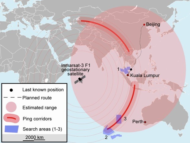
The image above illustrates equidistant rings around the satellite determined from BFO and BTO data. Note that the full range of the satellite’s signal detection capability emanates outward, exhibited by the grayish colored circles. From only this data, the satellite cannot discern from which direction the signal propagated, only the distance.
The red circle outlines the entire area from which the transmission could have come from MH-370 based on the total possible flight range of the aircraft. The red-lined arc represents the distance between the satellite and the source signal as measured through BTO and BFO data. When these two datasets are combined, the aircraft’s location can only follow that one arc. In short, the bold-faced red line represents the only area the flight could have been during its handshakes with the INMARSAT satellite, what Richard Godfrey named the “candidate flight path.”
Adding WSPR to INMARSAT data to track the aircraft
The BTO and BFO were never designed or previously used for locating a vessel until MH-370 disappeared, so Richard Godfrey also thought to try and supplement that data with another kind: Weak Signal Propagation Report (WSPR). According to him:
WSPR is a digital radio communication protocol designed for weak signal transmission. WSPR uses frequency-shift keying and forward error correction to reliably send data tens of thousands of miles with just a few milliwatts of power. WSPR was designed to test radio signal propagation.
Godfrey examined BTO, BFO, and WSPR data together and published his analysis in a paper titled “Using the WSPRnet and Inmarsat Satellite data in the search for MH370.” It is referenced herein as Godfrey; page number.
Notably, of the INMARSAT data, Godfrey pointed out that it does not provide localization. Rather, it can only determine “candidate flight paths” (Godfrey, p. 2). This is because the BTO and BFO reveal only how far the signal propagated from the location of the satellite.
The exact location of the target signal’s broadcast on that distance arc, however, cannot be discerned from this data alone. And that candidate arc comprises an enormous area, ranging from very far southwest of Australia, over the Tibetan plateau, nearly to the southern border of Kazakhstan.
Data points provided by the BFO and BTO occur every half hour (and less in this case because of the frequent system power-offs). WSPR, on the other hand, creates an average of thirty-four datapoints every two minutes. Throughout the time of the MH-370 flight, this comprised 7,708 links in the WSPRnet database.
Across the world there are 5,000 WSPR stations that document any “spots” or detections of certain radio transmissions. Furthermore, “The receiving station decodes the WSPR protocol of the transmitting station and enriches the data with its call sign, location, signal-to-noise ratio (SNR) and the drift up to ± 4 Hz/min.” To locate aircraft using this data, Godfrey looked for “anomalies in the received SNR and drift, which is analogous to looking for changes in the BTO and BFO” (Godfrey, p. 5).
According to Godfrey, aircraft passing through radio signals cause forward scatter (FS), side scatter (SS) and back scatter (BS). He explained:
We are looking for FS, SS and BS from the same transmitter at the same time, but picked up by different receivers. If FS is picked up on one TxRx link and SS on another TxRx link, at the same time and from the same transmitter, this can also give an indication of the approximate location of the aircraft. (Godfrey, pp. 5-6).
In sum, Godfrey claims that by looking for specific types of disruptions in radio signals, and cross-referencing their occurrences with BTO and BFO data, one could not only establish the distance from the satellite of a propagated signal, but also the location at specific times.
Several factors improved the odds of finding the aircraft this way, according to Godfrey. First, MH-370 traversed a very remote area, meaning that chances were good that detected radio interference came from that specific flight. Examiners could also distinguish other flights by their ADS-B data because under normal conditions the transponder remains powered on, and therefore detectable (see what this looks like here). This is, for example, how sites like Flightaware allow the public to track flights.
Second, contemporaneous to the MH-370 flight, the Earth underwent a solar peak. Solar radiation enhances ionosphere reflection, which is how High Frequency (HF) radio waves propagate. Grey Line propagation also contributes to long distance propagation of radio waves, which is particularly helpful for reaching such faraway places as the remotest parts of the Indian Ocean, where experts believe MH-370 went.
Basically, grey line propagation describes a phenomenon that occurs at sunrise and sunset where changes in the ionosphere result in lower attenuation across multiple frequencies at once, thus extending the range of all of them. MH370 appears to have still been airborne at sunrise.
It is beneficial here to allow Godfrey to explain himself the tactics he used and the results he found in his search for MH-370 using the WSPR methodology (Godfrey, pp. 14-17):
At 21:02 UTC [03:02 MYT] there was a stable link (no anomaly) on a similar propagation path just to the north.
Zooming in on this WSPR detection, the aircraft is detected 18 nm North of flight route T41 in the vicinity of waypoint BEBIM. Flight route T41 runs between YPCC Cocos Island Airport and waypoint RISMI to the West. There was no traffic on flight route T41 at 21:20 UTC [03:20 MYT]. The aircraft traffic to and from Oceania and the Middle East used either flight routes such as N509 or N640 or flight route L894 much further south…
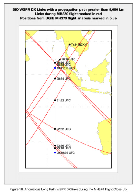
There are a total of 8 anomalous long path WSPR DX links between 18:20 UTC [00:02 MYT] and 23:48 UTC [05:20 MYT – MYT times would fall on March 8] on 7th March 2014…
What he is saying there is that WSPR detections occurred on flight paths with no known aircraft traversing them at the time of detection. Because these detections occurred within the range illustrated by the BTO and BFO data, they suggested the presence of MH-370.
From this examination, Godfrey eventually determined that MH370 crashed about 1,933 km (1,201.1 mi; 1,043.7 nm) due west of Perth at 33.177°S; 95.300°E and probably sunk to a depth of 4,000 m (13,123.4 feet) in a subsurface mountainous area with deep ravines and a volcano. The government of Australia, which conducted searches until 2017, released this statement regarding Godfrey’s analysis on February 16, 2022:
“The ATSB is aware of the work of Mr. Richard Godfrey and acknowledges that he is a credible expert on the subject of MH370, but the ATSB does not have the technical expertise to, and has not been requested to, review his ‘MH370 Flight Path’ paper and workings. As such the ATSB cannot offer an assessment of the validity of Mr. Godfrey’s work using WSPR data,” said ATSB Chief Commissioner Angus Mitchell.
“The ATSB does acknowledge that Mr. Godfrey’s work recommends a search zone for MH370, a significant portion of which covers an area searched during the ATSB-led underwater search,” Mr. Mitchell continued.
“When the ATSB was made aware that Mr. Godfrey’s zone incorporates an area of ocean surveyed during the ATSB-led search, out of due diligence the ATSB requested Geoscience Australia review the data it held from the search to re-validate that no items of interest were detected in that area.”
The ATSB expects that review to be finalised in coming weeks, the results from which will be made public on the ATSB’s website.
“The ATSB acknowledges the importance of locating the aircraft to provide answers and closure to the families of those who lost loved ones,” Mr. Mitchell said. “The ATSB remains an interested observer in all efforts to find the missing aircraft."
Mr. Mitchell reiterated that any decision to conduct further searches for MH370 would be a matter for the Government of Malaysia, and that the ATSB was not aware of any requests to the Australian Government from Malaysia to support a new search for the missing aircraft.
To date, no one has utilized Godfrey’s report or results to commence a search in the area he identified as the probable crash site. Perhaps this is because some do not think it is scientifically sound.
Is using WSPR a Valid Methodology?
The creator of WSPR, Joe Taylor—a Nobel Prize winner in physics—stated that it cannot “provide any information useful for aircraft tracking.” Victor Iannello provided a detailed exposition on why. He wrote that the signal-to-noise ratio (SNR) anomaly purported to reflect a disruption caused by the passing of MH-370 through the propagated radio wave did not represent an anomaly at all. Iannello concluded instead that:
At long distances and at low transmission powers, the received signals from hypothetical aircraft scatter are simply too weak by many orders of magnitude. What is claimed to be discernable “anomalies” in signal strength attributable to forward scatter by aircraft are within the expected deviations in signal strength for long distance skywave propagation involving refraction off the ionosphere.
In a follow up message upon reviewing Iannello’s brief article, Taylor stated “As I’ve written several times before, it’s crazy to think that historical WSPR data could be used to track the course of ill-fated flight MH-370. Or, for that matter, any other aircraft flight…”
One person who took part in testing the efficacy and utility of WSPR as a tracking tool agreed, determining that the method was not credible. Mike Glynn was an airline captain for Qantas and a former RAF pilot. He helped Godfrey conduct some preliminary tests. Based on his participation, he wrote the following:
When RG [Godfrey] produced his MH370 analysis it made little sense to me as an airline pilot. The track to the north of Sumatra is very irregular and I found it difficult to reconcile it to anything an airliner would fly…
In my opinion, the methodology used in the construction of the WSPR track does not conform to any known principles of aircraft navigation that I am aware of.
It is arbitrary in the extreme and, I believe, constructed only to satisfy the constraints of the only solid data available, the BTO and BFO data.
Glynn’s analysis is unclear. For example, his statement that “the WSPR track does not conform to any known principles of aircraft navigation that I am aware of” is rather vague. Does he mean here that MH-370 flew an unconventional path? If so, this would not seem to debunk Godfrey’s methodology because we would expect a hijacked plane to fly abnormally, even if the hijacker is a trained pilot.
Earlier in his commentary, he noted two tests of WSPR data—one that was accurate and another that was not. Godfrey and Glynn had compared WSPR data results to known flights to see if they reconciled. In the case of the incorrect results, Glynn noted that Godfrey “had been making some wrong assumptions regarding the aircraft type [and] weight.” He did not explain if this would simply cause a misreading of interference data, or if this somehow rendered invalid the efficacy of the methodology itself.
In the case where the test provided correct results, Glynn commented that “no documentation was given to me to substantiate how [Godfrey] had arrived at this conclusion.” Whether this suggested some kind of trickery or other nefariousness, Glynn does not offer an opinion.
Despite stating that he would provide a follow up to these comments, I could not find any piece from Glynn doing just that as of this writing.
Researchers at the University of Liverpool, however, have taken Godfrey’s claims seriously and are conducting their own analysis of WSPR data. Simon Maskell, Professor of Autonomous Systems with the University of Liverpool’s School of Electrical Engineering, Electronics and Computer Science, explains:
I strongly believe that a synergistic mix of statistics, data science and High Performance Computing (HPC) can be used to help find MH370. My team are using their expertise and know how in statistical modelling and Bayesian techniques to analyse vast quantities of WPSR data. We hope that our analysis helps in the quest to provide new evidence to support a new search and help locate MH370.
Maskell, Godfrey, and Dr. Hannes Coetzee published a peer-reviewed case study employing WSPR analysis of MH-370 in 2023. To date, there is not consensus on whether this type of analysis can truly locate the aircraft’s true path, but it remains under consideration and further study.
Satellite data is not the only source for locating the aircraft
This article discusses some ways in which the aircraft’s transmissions to and from satellites provide one method for tracking its potential course. While unable to precisely locate the final resting place, it does provide useful information toward narrowing down what otherwise would be an impossibly large search area. As the red circle in the image above shows, this specific Triple 7’s range was extraordinary—stretching farther than the distance from Perth, Australia, to Beijing, China.
Other datasets have been analyzed and can help constrict future potential search areas even further—should new searches occur. These datasets include oceanic currents, weather data, evidence procured from the wreckage pieces, and others. As this essay indicates, all of this is quite complicated and highly technical. Nevertheless, at some point later I hope to explore more of these subjects. And, as promised, I will eventually publish a piece on the pilots themselves.
To learn more about navigating aircraft, check out below.



Crazy we could lose anything like a passenger jet these days..