How do Pilots Navigate Airplanes?
There is a lot of tech to help, but what if it fails?
Visit the Evidence Files Facebook and YouTube pages; Like, Follow, Subscribe or Share!
Find more about me on Instagram, Facebook, LinkedIn, or Mastodon. Or visit my EALS Global Foundation’s webpage page here.
Recently, Newsweek posted a rather provocative headline:
The headline buries the lede a bit; it is not until the fifth paragraph that the outlet makes its primary point:
An uptick in GPS interference in eastern Europe in recent months has been blamed on jammers in Russia's Kaliningrad region, the exclave sandwiched between NATO members Poland and Lithuania that serves as a base for one of Russia's major naval fleets.
This article is not a commentary on whether Russian military forces are playing a role in this. Rather, regardless of whatever hostile entity might engage in navigation jamming activity, the question is what do airline pilots do about it? More broadly, how do aircraft navigate? The Newsweek article focuses on GPS, but modern aircraft possess a number of methods by which to determine their position and path. When I attended my first flight school courses, navigation was one of the first topics. For over a century, pilots have had to figure out where in the world they were, where they were going, and how to get there. As with any technology, reliance upon it without understanding some fundamental principles is a mistake. Technology fails, so operators need to be prepared. Given the nature of commanding an aircraft, pilots have a particularly important obligation to know what to do when modern systems go down.
In the Old Days
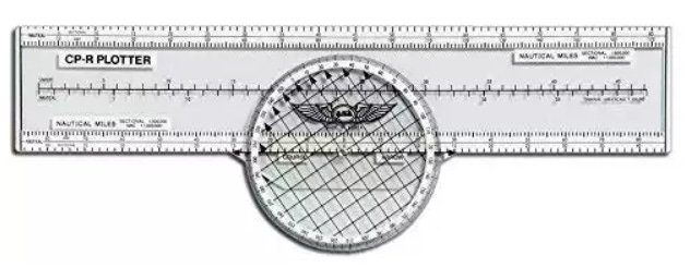
Before GPS and electronic beacons, pilots adopted the same navigation method as sea-faring captains did long before. Using hand-drawn or machine-printed maps, pilots plotted points and measured the distance between them. Angular measurements allowed pilots to determine the heading needed to follow a specified path. Magnetic compasses helped keep the aircraft on the selected heading. Plot points often aligned with visual references, such as shorelines, mountains, rivers, or other features recognizable from the air. Even when those landmarks were hard to see, establishing the heading and tracking the plane’s speed allowed for quite accurate navigation. To determine the expected time to reach a certain destination or rendezvous point, aviators employed basic math (airspeed and distance). For a simple illustration, if two points sit 100 centimeters apart on a map, and each centimeter represents a kilometer in the real world, then an aircraft flying at 100 kilometers per hour will move from one point to the other in one hour. Note: pilots usually measure speed in knots—1 knot is the equivalent of 1 nautical mile per hour [or 1.852 km/h]—but we are keeping it simple here. When plotting points, it helped to keep them relatively close together—within about 100 nautical miles of each other. In low visibility or over long distances, it would be easy for a flight crew to miss a plotted point and veer off course. Moreover, the Earth is a globe (sorry flat-earthers, but it is true), so long distances between points might lead to gross deviations if plotters failed to take into account the spherical shape.
Sample ASA Rotating Plotter; Credit Thrustflight.com
Pilots faced conditions that rendered this sort of navigation challenging at times. Cross winds or changing visibility conditions easily push aircraft off course. Though less frequent, cosmic events could disrupt the calibration of a pilot’s compass, which works by the magnetic attraction between the compass needle and magnetic north. Moreover, plot-point navigation required strenuous attention to speed, heading, conditions, and visual cues to keep true throughout the flight. Nevertheless, when all else fails, it is still possible even for a modern jet to sustain the proper course through this process.
Radio Navigation
First used in the 1920s, Radio Navigation evolved from a fairly crude methodology to one sophisticated enough that it remains in use today. Rotating stations on the ground (or on a boat) transmitted radio waves with an embedded identifier. The identifier consisted of three letters given in Morse Code, which allowed the pilot to determine which beacon’s signal he/she was receiving. In the early days, aircraft did not receive the signal until the ground station faced their direction, though that has since changed. By calculating the signal strength and the rotation speed of the ground beacon, pilots could calculate their position in relation to the location of the beacon.
A more advanced version of radio navigation is called Very High Frequency Omni-Directional Range (VOR). VOR beacons have a range of about 200 miles, and provide both directional and distance information. These, too, use Morse Code identifiers so pilots know which signal belongs to which beacon. This system consists of multiple components: Antennas, Receivers, and DME (Distance Measuring Equipment). DME calculates a straight-line distance from the aircraft to the VOR by transmitting a UHF signal between the onboard device and the on-ground one. Especially for those flying private planes, combining VOR with DME provides quite precise navigation data. Nonetheless, while VORs remain important navigation tools in many places in the world, in the United States and Europe, newer systems continue to replace them.
Another form of radio-driven navigation remains in wide use in commercial aviation—the Instrument Landing System (ILS). This system employs a Localizer and Glide Slope, and in many cases, approach lights. The localizer sits at the very end of a runway and broadcasts two signals at 90 and 150 Hz. Equipment aboard incoming aircraft receive the two signals, and when they align it indicates that the plane is proceeding directly along the centerline of the runway. While the localizer establishes inbound flights on the centerline (or, confirms their lateral position), the glide slope guides vertical positioning. Like the localizer, the glide slope emits two signals—roughly perpendicularly to the localizer—to situate the plane on an appropriate descent path. Following the intersecting radio signals allows the aircraft to descend at a safe 3-degree angle.
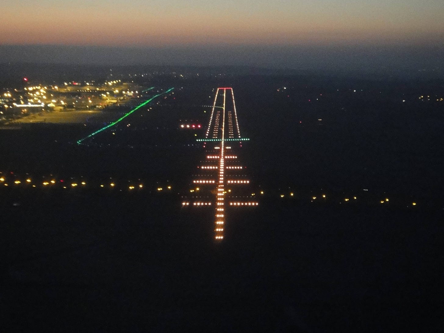
Approach lighting helps pilots track their landing trajectory in low-light or low-visibility conditions. These are the spectacular arrays that precede the runway.
Typical approach lights; credit: century-of-flight.net.
Many airports also have Precision Approach Path Indicator (PAPI) lights next to the touchdown zone. In the image above they are on the left side just beyond the green strip. PAPI lights contain four horizontal illuminators (here, two red, two white). The color of the lights indicate whether the aircraft is properly following the glide slope. White means the plane is above the proper slope, red means below. Pilots want to see two of each, which indicates that the aircraft is right in the middle of the glide slope and, thus, properly descending. Just as “lefty loosie, righty tighty” describes the direction to turn a lid or screwdriver, there is also a saying for remembering the purpose of PAPI lights: “All white, you're high as a kite. All red, you're dead.” ILS allows pilots to land in pretty severe conditions, such as thick fog or heavy rain.
The beauty of radio navigation is in its rich history and clever application to new systems. As a ground-based technology, radio navigation remains a stalwart backup when satellites fail because of cosmic rays, mechanical malfunctions, or other causes. For this reason, the headline with which this article opened seems a little less dramatic. In any case, radio navigation is being replaced by GPS as the primary navigation method, so here is how it works.
Global Positioning System
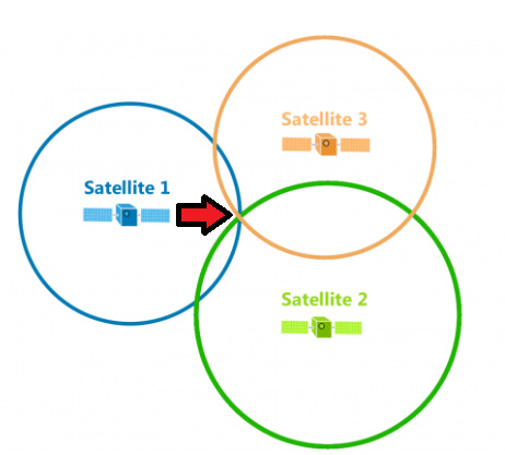
Virtually everyone alive has by now heard of GPS, but few truly understand how it operates. The breakdown here applies to GPS generally, whether in use in an automobile, on a smart phone, or in an aircraft. Critical to the GPS system is a network of 30+ satellites that orbit the Earth in medium Earth orbit (MEO) at an altitude of approximately 20,200 km (12,550 miles). GPS receivers on the ground ‘listen’ to whichever of these satellites are within line-of-sight to determine how far away each is from the receiver. To accurately determine the receiver’s exact ground position, it must calculate distances from at least four satellites. From these distances, the receiver calculates its latitudinal-longitudinal position via trilateration. To visualize this, imagine that information received from a single satellite creates a circle anywhere within which the GPS receiver might be located. Do this four times with data from four different satellites, and, like a Venn diagram, the actual location lies where all the coverage areas converge. (See the arrow I added to the image below).
Source: gisgeography.com
Another crucial element of the functionality of the GPS system is an aspect of Einstein’s Theory of Relativity. This effect, called gravitational redshift, works as follows:
The wavelength of electromagnetic radiation will lengthen as it climbs out of a gravitational well. Photons must expend energy to escape, but at the same time must always travel at the speed of light, so this energy must be lost through a change of frequency rather than a change in speed. If the energy of the photon decreases, the frequency also decreases. This corresponds to an increase in the wavelength of the photon, or a shift to the red end of the electromagnetic spectrum.
Clocks on Earth function under the pressure of stronger gravity than those in orbit. Therefore, clocks on Earth tick at a slower rate than those aboard satellites. For GPS to accurately locate a ground receiver, the deviation between clocks must be taken into account. Failing to do so could result in location errors of up to 50 meters (164 feet). (This concept also illustrates the impossibility of a flat earth). By correcting this measurement disparity, GPS’s error rate today falls between 0.64 m (2.1 feet) and 2.0 m (6.6 feet) 95% of the time. Commercial aviation employs GPS as its primary navigation tool now because of its accuracy and the fact that it is transmitted from space making it accessible anywhere in the world (unlike ground-based navigation tools that cannot reach flights in more remote areas such as mountain ranges or distant parts of oceans).
GPS Interference
Newsweek’s headline says GPS “jamming,” but the article also talks about “spoofing.” These are two different things, one potentially more dangerous than the other. GPS jamming is not new. Military forces jammed commercial GPS systems at least as far back as 2012. Jamming is little more than a brute forced denial-of-service attack on the bandwidth used by specific satellites. Basically, a military unit inserts a bunch of “noise” on the same frequency, which obfuscates or obliterates the information that receivers intend to ‘hear.’ This is similar to when two or more radio operators try to broadcast on a single-use channel. What the listener gets is either no sound or unintelligible garble. For an airliner, onboard GPS equipment would simply fail to provide any information. This is not particularly dangerous because pilots will immediately recognize the failed system and thereby switch to another navigational method. Airliners still use VORs and DME as backups.
Spoofing, on the other hand, takes a more nefarious approach. While spoofing can also result in a complete blockage of data, more sophisticated attacks replace real information with falsified data. For an aircraft utilizing GPS to guide it along its path, one can see how serious is the problem of false information. C4ADS, a non-profit that tracks attacks against public infrastructure, identified “10,000 instances in which Russia interfered with satellite navigation of more than 1,300 civilian vessels in ten different locations around Russia, Ukraine, and Syria.” In its technical report, C4ADS explained how spoofing occurs:
GNSS spoofing is the deliberate transmission of signals designed to emulate the authentic satellite systems that underpin much of the world’s critical infrastructure. GNSS spoofing is distinct from other forms of navigation interference such as GNSS jamming, which simply drowns out satellite signals to prevent receivers from using them. Instead, spoofed signals are able to force vulnerable GNSS receivers, like those installed on [an oceanic or airborne vessel], to lose their lock on authentic satellite signals and instead lock on to the signals generated by the spoofing device. Once a receiver locks on to the spoofed signals, the spoofing transmitter can relay false position or timing information to the victim receiver, thereby “taking control.” [Citations omitted].
This attack method targets the receiver of the GPS information to forcibly connect with it by tricking it into believing that the malicious actor’s device is the satellite. In other words, the attacker effectively convinces the receiver to authenticate the attack device and ignore the real one (GPS satellite). Then, any information disseminated from the attacker is perceived by the receiver as legitimate. American law enforcement agencies adopt a similar strategy for capturing cellphone transmissions through the use of a tool called a stingray.
The US Federal Aviation Administration (FAA) and the European Union Aviation Safety Agency (EASA) regularly convene to discuss the ongoing and growing problem of GPS spoofing. For example, they have deployed reporting regimes, issued safety guidance bulletins, and now require commercial airlines to maintain backup databases of information to enable pilots to readily switch to more conventional navigational tactics. Unfortunately, it seems no one has yet developed an effective defense against advanced spoofing attacks directed toward GPS systems specifically. For now, the above measures as well as enhanced pilot training remain the aviation sector’s response strategy until such time as a technical solution is found.
Calling All Cybersecurity Specialists
Reuters media notes that aviation experts generally believe this will be challenging to solve technology, quoting one as follows: “As GPS interference attacks become more sophisticated, technical solutions would have to be consistently updated, creating a game of cat-and-mouse.” Alas, such is the world in which cybersecurity specialists live. Nonetheless, this hardly provides a reason to abandon the effort. With numerous large-scale conflicts occurring across the world, and certain governments partaking in efforts to unleash global chaos for whatever reasons, cybersecurity specialists have an acute opportunity. Solving—or even mitigating—the problem of GPS jamming and spoofing, particularly in aviation and maritime transportation, would elevate that analyst to stardom. For those in the cybersecurity space looking for a challenging problem, here one sits right upon the doorstep.
Make no mistake, the problem is complex and evolving. One must understand spoofing techniques, the methodologies by which satellites broadcast data, and the science behind the transmission medium. It may also require some knowledge of avionic systems, which assuredly vary to some degree among manufacturers. That said, anyone reading this who wishes to partake in this challenge, feel free to reach out to me for guidance on how to find information on these topics. For everyone else, rest assured that failures in GPS will not bring down airplanes. Commercial pilots train extensively for any number of system failures. Redundancy in commercial aviation is a foundational principle. This goes for systems and pilots. If GPS fails, your flight crew may be whipping out their charts, rulers, and pencils, but they will figure out where they are and where they are going. And you will eventually find yourself on the tarmac of your destination airport without a hint of any issue at all.
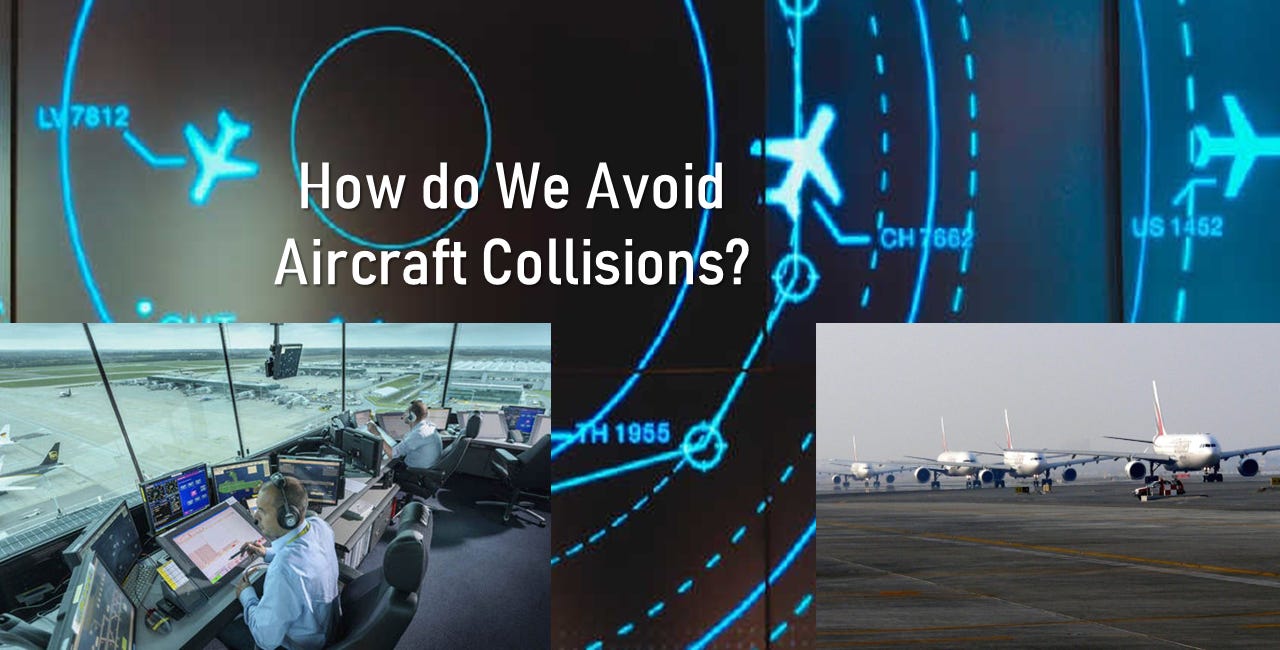
For an article on the systems used to prevent close calls among aircraft, click below.
***
I am a Certified Forensic Computer Examiner, Certified Crime Analyst, Certified Fraud Examiner, and Certified Financial Crimes Investigator with a Juris Doctor and a Master’s degree in history. I spent 10 years working in the New York State Division of Criminal Justice as Senior Analyst and Investigator. Today, I teach Cybersecurity, Ethical Hacking, and Digital Forensics at Softwarica College of IT and E-Commerce in Nepal. In addition, I offer training on Financial Crime Prevention and Investigation. I am also Vice President of Digi Technology in Nepal, for which I have also created its sister company in the USA, Digi Technology America, LLC. We provide technology solutions for businesses or individuals, including cybersecurity, all across the globe. I was a firefighter before I joined law enforcement and now I currently run a non-profit that uses mobile applications and other technologies to create Early Alert Systems for natural disasters for people living in remote or poor areas.




Would be nice to jam the jammers