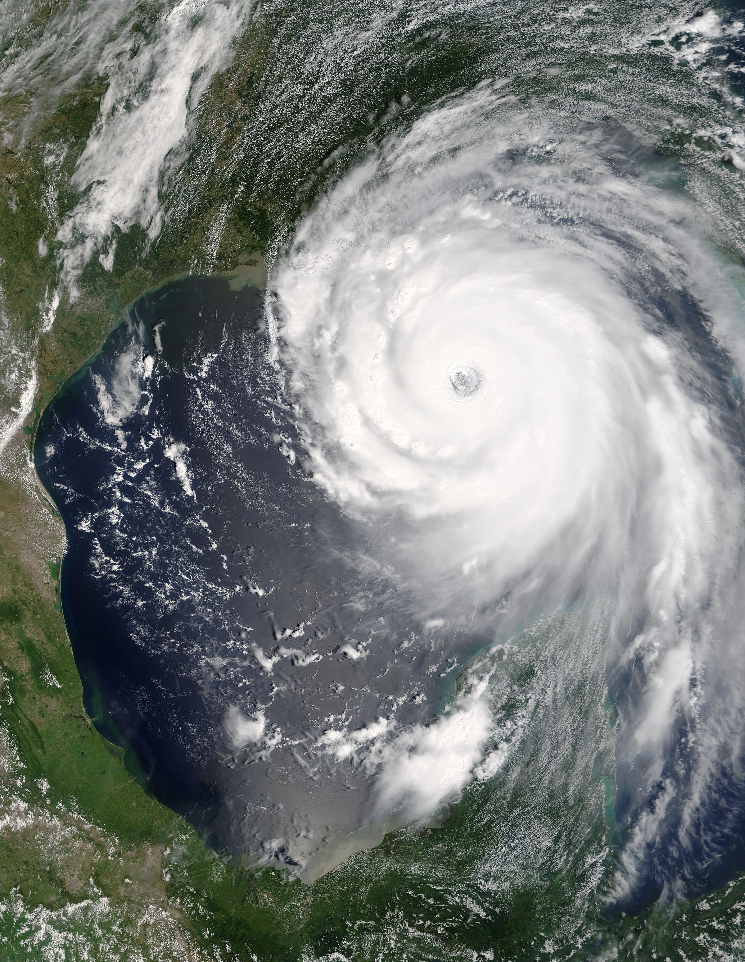
Hurricane Katrina as seen from the sky on August 28, 2005. (public domain)
In recent days, two hurricanes have assaulted the United States. Hurricane Helene, a category four, made landfall on September 26. It killed more than 200 people, making it the deadliest to hit the mainland in fifty years. Another one, named Milton, struck parts of Mexico and central Florida on October 9, making landfall aa a category three. Over just 24 hours, that storm escalated from a category two to a category five while over the Gulf of Mexico, the highest level. It was one of the swiftest growing storms on record.
The National Oceanic and Atmospheric Administration (NOAA) defines a hurricane as:
A rotating low-pressure weather system that has organized thunderstorms but no fronts (a boundary separating two air masses of different densities).
Hurricanes are rated by category based on their wind speeds in accordance with the Saffir-Simpson Hurricane Wind Scale. At its lowest—a category one—wind speeds range between 74 and 95 mph (119 - 153 km/h). Category fives reach and exceed 157 mph (252 km/h). For Atlantic Hurricanes (those that form over the Atlantic basin, which includes the ocean and Gulf of Mexico), the typical season spans from June 1 to November 30, although outliers occur about 3% of the time.
The size, scale, and destructive force of these storms are extraordinary. While we can easily see the results—death tolls, shattered homes, flooded streets, and so forth—understanding the mechanics is a separate matter.
Formulation
Generally, hurricanes require several phenomena to occur for them to form, and even then the result is not guaranteed. These baseline factors include a tropical wave, warm ocean water, thunderstorm activity, and low wind shear.
A tropical wave is the crucial starting element, contributing to the formation of at least 85% of Atlantic hurricanes of category three or higher. Tropical waves are elongated areas containing lower air pressure than the surrounding environment. They normally form north to south, and move east to west. Sometimes, tropical waves end up as ‘simple’ thunderstorms; other times they pick up warm tropical air and develop into more organized systems.
In the latter case, for those that become hurricanes warm air is drawn upward into a column as the system moves laterally (usually east to west, but as Milton has shown, this is not always the case). A cycle of evaporation and condensation progressively feeds the cloud column, causing it to grow in height and bulk. This is bolstered when the disturbance moves through existing clouds and assimilates them into the system.
Near the top of the column, the warm air cools and destabilizes. Energy released from the cooling vapor in the air creates high pressure there. Air is forced out by the pressure in the form of wind that begins to circulate throughout the system. This eventually coalesces into a circular motion, which evolves into the more recognizable pattern of a hurricane.
Meanwhile, pressures between the bottom of the storm system and the ocean surface precipitously drop. The wind forced out from the high pressure at the top streams toward the low pressure zone where it rapidly warms and rises back up toward the high pressure area. As the cycle continues, the hurricane structure takes shape and the wind rotation increases.
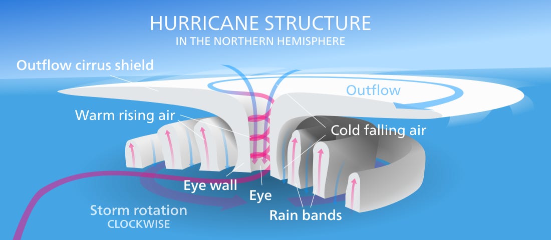
Source: Kelvinsong [CC BY 3.0], via Wikimedia Commons).
Once the system becomes fully organized, it grows stronger by continuing to draw in warm water and air. The center—or, the “eye”—becomes calm because warmer air and water funnels upward like water entering a drain (represented in pink, above). As this material is ejected outward from the top-center and rushes back toward the low pressure area near the surface, the Coriolis effect forces it into a circular motion. Depending on the hemisphere in which the storm is located, it will move in a clockwise (southern) or counterclockwise (northern hemisphere) direction.
The Coriolis effect describes the phenomenon wherein an object at the equator travels faster throughout Earth’s daily rotation than one closer to the Poles. The distance moved over 24 hours of Earth’s evolution is much greater at the equator than at the Poles because of the size and shape of the planet, thus an entity there moves faster to cover that distance over the same amount of time.
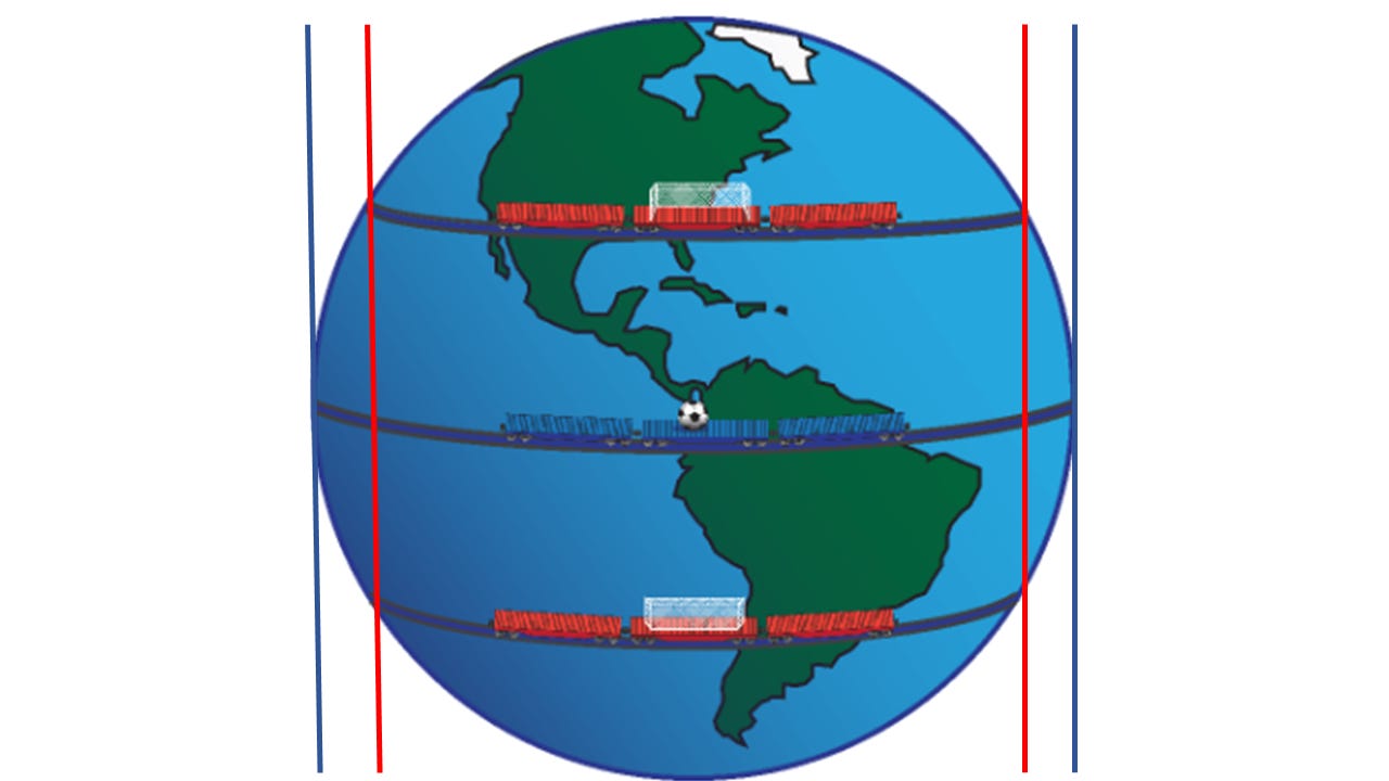
To visualize this, draw parallel tracks around a sphere, one at the center and the others nearer the top or bottom. If parallel, the tracks farther from the center will be decidedly shorter in length.
Note the distance differences between the red lines and blue.
As anything, including wind, moves northward or southward, it is manipulated by this effect. When winds are pushed out from the high pressure roofs of tropical storm systems, they rush to fill the void of low pressure at the bottom. Coriolis forces twist them into curved patterns, which creates a spinning effect as the system advances.
Wind shear works against hurricanes and can destabilize them to the point of destruction. Basically, wind shear describes winds that change direction or speed over very short distances. Vertical wind shear can inhibit the formation of the circular pattern of a hurricane, thereby preventing it from organizing enough to build speed or power.
Horizontal wind shear can create similar distortions in the vortex progression of the storm, or it can pull the entire system away from its warm water feeding source more quickly than the storm can grow. In some instances, wind shear disturbances can introduce cold fronts that decrease the pressure differential necessary for hurricanes to grow.
Where’s the lightning?
If you have ever endured a hurricane from within, you may have noticed a peculiar absence of lightning. While some do produce it, strikes are few and rare, and more often altogether absent.
Lightning typically requires the upward and downward motion of air. In a thunderstorm, water vapor is drawn into the higher clouds while hail and ice fall downward. As these particles collide, they clump together to form graupels. Heavier than the surrounding air, the graupels will fall back toward the ground. As graupels descend and impact vapor moving upwards, the graupels rip electrons from it creating an electrical imbalance.
Electrons—which are negatively charged—clinging to plummeting graupels collect at the bottom of the thunder cell while the top becomes positively charged due to the depleting number of negatively charged particles. This leads to the formation of an electric field between the top and bottom. Eventually, the imbalance becomes unsustainable causing a bolt of electricity to leap from one to the other to restore the balance. This manifests as ground-cloud or cloud-to-cloud lightning strikes.
In most cases, as hurricanes strengthen, the occurrence of lightning decreases. Unlike in thunderstorms, most of the air and vapor in a hurricane swirls around, not vertically. The smoothening of the circular orientation lowers the opportunity for particles to collide with enough force to shave electrons, thereby prohibiting the electric field generation necessary to create charge leaps (i.e. lightning strikes). Scientists use the frequency of lightning strikes as a visual indicator of rising or lowering intensity of a hurricane.
Storm surge
Storm surge describes the amount of seawater pushed toward land by a moving hurricane. The exact amount is difficult to predict because the effect is sensitive to subtle changes in the storm or the surrounding environment. Depth of the water also makes a significant difference. Shallow water is far more reactive to storms because wind can more easily push lower volumes. It is for this reason that Lake Erie, the shallowest of the Great Lakes in the northern United States, was historically the most dangerous for ships.
Other factors influence the destructive damage of the storm surge. Open coastlines, shallow waters, the slope of the continental shelf, and the composition of the shore itself all make a difference. Generally, the fewer obstacles there are to the infiltration of ocean water onto land, the worse the damage that will probably result. Additionally, natural tidal flow can exacerbate the surge (high tide boosts storm surges).
Powered by the fierce winds of a hurricane, the storm surge tends to be the most destructive force. Not only does it cause the damage expected from vast amounts of water breaching the land, but it contains considerable erosive power. As water weighs 1,700 pounds per cubic yard, its constant smashing into structures as it is forced upon land by the wind has a devastating effect.
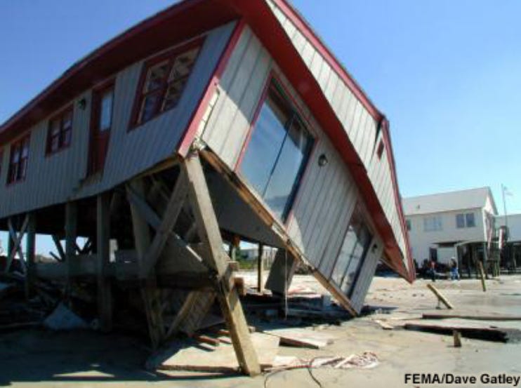
This house crumbled under Hurricane Floyd’s 15 ft (4.5 m) storm surge in 1999.
Because so many factors affect the severity of the storm surge, some of the worst cases in US history did not come on the heels of the biggest storms. Hurricane Ike in 2008, for example, blasted the Galveston Bay area of Texas with surges nearing 20 ft (6m), although when the storm made landfall it was a category two. Katrina pummeled New Orleans with a 28 ft (8.5 m) surge, at which point the storm was a category three. New Orleans sits mostly below sea level and the shoreline there is very shallow. It became the most catastrophic hurricane in US history both in damage and loss of life.
Villainous accomplices - Tornadoes
Hurricanes sometimes bring their destructive cousins—tornadoes. Historically, hurricane-generated tornadoes have been weak, comprising subsystems of the forward right quadrant of the larger storm. Because both hurricanes and tornadoes form from pressure differentials that generate swirling air, they are effectively close relatives. But normally, hurricanes hoard so much of the energy that tornadoes—when they do form—tend to flit in and out of existence with little fanfare.
In Florida during Hurricane Milton, however, the situation differed. Northern Illinois University meteorology professor Victor Gensini proclaimed that the situation there was “definitely out of the ordinary.” He was referring not only to the number of tornadoes that spun off of Milton, but also their ferocity. According to St. Lucie County Sheriff Keith Pearson, at least a dozen tornadoes were confirmed to having touched down in the county shortly after the hurricane’s landfall. By 8 pm on October 9, the state had issued 126 tornado warnings and confirmed at least 19 touchdowns. Damage from these could not yet be calculated as of this writing.
Tornadoes can form when hurricanes reach the land because they depend upon surface friction. If the outflowing air of the hurricane and this surface friction combine just right, tornadoes emerge. Wind shear actually increases the odds of tornado development because funnel clouds thrive when “you have a change in wind speed and often direction.” Why this occurred in such elevated numbers in Florida will surely be a topic of study in the coming months.
Hurricane energy and Earth’s “budget”
The amount of energy released by a hurricane is nothing short of astonishing. A single storm’s winds alone can generate and release nearly half as much as “the electrical generating capacity of the entire world.” The energy released by the formation of clouds and rain exceeds that—by a lot.
NOAA refers to the energy release associated with the condensation of water droplets as latent heat. Latent heat is defined as the “amount of heat added to or removed from a substance to produce a change in phase.” Here is how scientists calculate it:
An average hurricane produces 1.5 cm/day (0.6 inches/day) of rain inside a circle of radius 665 km (360 n.mi) (Gray 1981). (More rain falls in the inner portion of hurricane around the eyewall, less in the outer rainbands.) Converting this to a volume of rain gives 2.1 x 1016 cm3/day. A cubic cm of rain weighs 1 gm. Using the latent heat of condensation, this amount of rain produced gives 5.2 x 10¹⁹ Joules/day or 6.0 x 10¹⁴ Watts.
Norman Loeb, from NASA’s Langley Research Center, describes Earth’s energy budget as “the balance between the radiant energy that reaches Earth from the sun and the energy that flows from Earth back out to space.” Twenty-nine percent of that outflow is done through atmospheric reflection. The remaining 71% occurs through evaporation, convection, and emission of thermal infrared energy. One quarter of the energy that breaches the atmosphere is used in the phase conversion of liquid to gas—evaporation.
When the Earth’s energy budget enters a state of imbalance, the results can be chaotic. For example, the most obvious consequence is warming at the surface. A second effect is the increase in dangerous atmospheric disturbances driven by elevated rates of energy conversions, such as evaporation.
Scientists have observed how seasonally-driven energy imbalances effect conditions on Mars. Substantial imbalance leads to gross variations in surface temperature and, thus, atmospheric pressures. As the tendency of all systems is to restore equilibrium, Mars endures massive storms driven by pressure differentials that last for weeks and can cover the equivalent area of continents on Earth.
While the energy disequilibrium on Mars comprises an order of magnitude greater than here on Earth, the Earth’s atmosphere is far more complex than Mars’ atmosphere. Turbulence here creates graver danger in the form of winds and water.
Storms on Earth play a direct role in and are a result of the energy balance cycle.
First, it is important to note that there remains some debate about whether warming global temperatures will increase the frequency of category-rated storms. What is almost entirely not in dispute, however, is whether warmer temperatures will increase the severity of hurricanes. They will.
This has already been observed and measured from 1975 to 2013. Another study that examined hurricanes from 1986 to 2015 noted an increase of intensification by 4.4 mph per decade. A 2019 paper parsed these numbers between natural and anthropogenic causation, finding that natural variations cannot explain the full breadth of intensification.
Hurricanes serve as part of the evaporation process. As less energy is released back through the atmosphere because of the greenhouse effect, there will be a disproportionate amount remaining at the earth’s surface. This manifests as heat, which creates more powerful updrafts as storms begin to form. Because ocean water absorbs a substantial amount of heat, an abundance of warm water will provide additional fuel for the formulation of these storms. Indeed, right now the Gulf of Mexico is at or above record temperatures, which undoubtedly has contributed to the strength of Hurricane Milton.
As these conditions combine, pressure differentials will widen allowing hurricanes to cycle faster, strengthening wind and consuming greater amounts of water. Already, hurricanes can reach hundreds of miles in diameter. If the geographic area with contributing conditions widens, hurricane systems will have room to expand beyond anything we have seen in modern human history. Increased warmth will then contribute to their power potentials.
Can we capture this awesome amount of energy?
With such a massive output of energy, one should not be surprised that some scientists and engineers have explored the possibility of whether we could capture some of the raw power of a hurricane. Atsushi Shimizu, an engineer in Japan, has proposed an idea to do just that.
He has designed a “typhoon turbine,” a redesigned windmill that can purportedly withstand the wicked winds of rotating storms. Challenergy, Shimizu’s company, built a turbine that centers its generative properties on a vertical axis. The device is without propellors, using cylindrical cones instead, allowing it to withstand much greater wind forces. The company describes it as follows:
[Callenergy turbines] generate electricity via the Magnus effect, a phenomenon that occurs when a spinning object moves through a fluid, or air. It is the same phenomenon that causes a ball in baseball or tennis to curve when spin is applied.
In December 2023, Japan’s Environment Ministry set up one of these turbines at a rehabilitation facility for wild birds in Kushiro, Hokkaido. The Challenergy wind turbine rotates more slowly than conventional windmills, and its “tubes” are much smaller than normal propellors. The government is testing both its efficacy in storms and its safety for birds.
The goal of the company is to create both commercial devices for large-scale production, but also smaller ones that mount on houses and other buildings to gather and store energy from Japan’s famous typhoons. Whether they succeed remains to be seen.
Don’t mess with disaster
Having worked in the disaster field throughout much of my career, I implore you not to tangle with nature. One cannot fully comprehend the power of these storms often until it is too late.
I was awarded in 2012 by my local government for pulling a teenage boy from floodwaters. Without hesitation, four of my fellow rescuers and I jumped into a raging river to try and save him. Normally, that waterway registered as little more than a serene creek. On that day, however, it had surged by more than five feet from excessive rain in the days prior. Words fail to describe the force applied against us when we entered.
The message here is do not mistake one’s bravery for wisdom. Hurricanes and other natural disasters pay no heed to the interests of humans. They wield a power that carves canyons, reshapes coastlines, and chisels boulders. Despite millennia of advances in engineering and building construction, floodwaters still obliterate whole cities.
When a storm bears down upon your hometown, channeling energy equivalents to the entirety of human technological output, there is no cowardice in fleeing. As Katrina showed, remaining behind can be a death sentence. While it is tragic to lose one’s home and belongings, it remains preferable over losing one’s life. When authorities tell you to go—go.
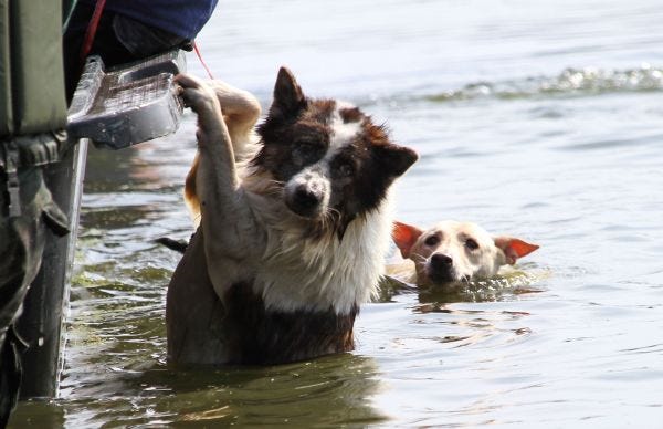
On a last note, if you are forced to flee for your life, do not forget that your pets must do the same. Contrary to a still popularly-held belief, domesticated animals are no more equipped to survive the devastation of natural disasters than humans. If you leave them behind, they are almost sure to suffer and probably perish. If you would not do this to your human family, do not do it to your furry one.
For more information on planning strategies for your pets prior to a disaster, click below. Stay safe out there.


I do wonder if the governments of the world that are messing with the weather making it rain or whatever they're doing is contributing to all this