Visit the Evidence Files Facebook and YouTube pages; Like, Follow, Subscribe or Share!
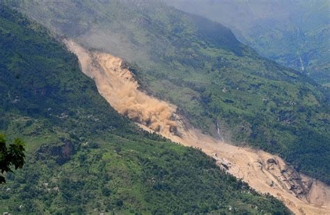
Landslides are a common occurrence in Nepal due to its seasonal monsoon rainfalls, steep topography, and erosion. From 2020 through 2022, an average of 193 people were killed per year by landslides according to the Government of Nepal’s Disaster Risk Reduction Portal. This number correlates with a generally rising trend in annual deaths associated with landslides and floods since the 1990s, but is in part caused by the extraordinary increase in the total number of landslides happening each year. Heavy rainfall or Glacial Lake Outburst Floods (GLOFs) can cause cascading water to swiftly destabilize ground structure leading to the rapid and destructive movement of rock, earth, or surface features (such as topsoil and vegetation). Deglaciation has been shown to contribute to landslide acceleration, and has helped to cause what appears to be a rise in the numbers and total volume of glacier lakes (pages 234-235). More glacier lakes, of course, means an elevated risk of catastrophic GLOF events. Furthermore, in many places in Nepal, roads constructed without planning for landslide and other erosion effects have contributed to increased numbers of landslides in their immediate proximity.
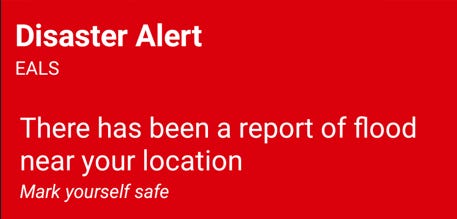
My foundation is working to create a comprehensive Early Alert System for natural disasters, and landslides are among them. Many methodologies have been proposed for providing advanced warning for landslides, but unlike detecting an impending flood or wildfire, predicting landslides is a trickier affair. Floods and wildfires show themselves gradually (generally), and usually follow a measurable trajectory allowing some warning to communities along the projected path. Landslides, however, seem to occur instantaneously thereby leaving no time for notice. Nonetheless, scientists now know many of the causal factors and can at least create general risk ratings based on a variety of conditions. Increasingly advanced technologies are enhancing the accuracy of such ratings. Technologies focused on dissemination of information, such as what we are developing at EALS Global, allow us to collect all of these new data sources, interpret them, and distribute them in the form of the most comprehensive, swift, and accurate advanced warnings possible.
So, how does one even begin to predict a landslide?
With hundreds of landslides occurring in Nepal every year, tracking them—let alone predicting them—is an extremely challenging endeavor. Perhaps the most technologically advanced effort toward landslide detection and prediction is being conducted by NASA’s Goddard Space Flight Center (GSFC). GSFC uses the Landslide Hazard Assessment for Situational Awareness (LHASA) model to combine landslide mapping and precipitation data, interpreted through machine learning, to create a near-real-time monitor of landslides. The International Centre for Integrated Mountain Development (ICIMOD) has developed a system called the High-Impact Weather Assessment Toolkit (HIWAT) that uses a weather prediction model partly fed by the Global Precipitation Measurement (GPM) satellite constellation to better forecast significant weather events across the Himalayan region. When combined—LHASA’s landslide inventories and ICIMOD’s high-impact weather data—the result is a relatively powerful predictive tool for landslides, which produces data that can readily be incorporated into Early Alert Systems like that created by EALS Global.
Source: https://www.nytimes.com/2014/08/03/world/asia/landslide-in-nepal.html?referrer=
Scientists create landslide inventories from a variety of datasets, including historical occurrences, field surveys, geomorphological mapping, image analysis and many others. The most recent proposal for developing landslide inventories is the multi-temporal (MT) landslide mapping method. This type of mapping provides a historical map of past occurrences, as well as more up-to-date information that gives context for the conditions surrounding landslide events, such as precipitation or seismic events. It also provides an analysis of the evolution of landscape conditions, which may result from seismic, climatic, or manmade events. MT landslide inventories enable the study of spatiotemporal patterns of landslide events, which allows scientists to comprehend the longer term effects on the surrounding terrain, an important element toward creating better predictive tools.
Primarily limiting this method, however, is that it relies upon high resolution satellite imagery, a measuring method often obfuscated or altogether defeated by atmospheric conditions and image artifacts. Technologies exist to overcome these obstacles, such as imagery generated by Synthetic Aperture Radar (SAR), but they have not been incorporated to scale on this problem as of yet. The expense of obtaining an adequate volume of high enough resolution imagery remains a serious issue. Machine learning also has not fully replaced the human intelligence factor in analyzing the imagery to develop this type of modelling, as programming AI for this task does not seem to have reached sufficient capability to date. As I have written about AI previously, a major deficiency here is the unpredictability of AI learning when the input data constitutes years’ worth of satellite imagery taken by different apparatuses, slight-to-severe variations in the landscape characteristics of images covering the same geographic space, and other less obvious potential bias vectors. Nonetheless, human beings continue to pursue development of models like the MT method, while programmers work to improve the results of AI driven programs.
Programs such as NASA’s LHASA 1 and 2.0 provide at least a baseline record of landslide risks, that can allow near real-time general notice when combined with programs like ICIMOD’s HIWAT. As MT models grow ever-more sophisticated and eventually fully automated program managers can enable live-stream data channels (through APIs or other resources) to allow other technology platforms to create effective, accurate, and localized Early Alert Systems for communities facing multi-hazard conditions. The EALS system is designed to rapidly integrate newly realized data streams for interpretation and conversion into standardized and simplified Early Alert notices to the largest number of recipients possible. And that recipient pool grows annually as mobile cellular and internet driven communications become cheaper and more widely available. In addition, the tech team at EALS Global is working on initiating information sharing across devices that does not rely on either internet or cellular networking. I am currently on the ground in Nepal launching testing procedures for establishing these technological methods of communication. It will take time as the specific conditions of Nepal’s rural areas, situated as they are in the high mountains or low Terai, require continuous and out-of-the-box problem solving.
All of these procedures take time, manpower and money. EALS Global is the manifestation of my vision to put technological creativity and expertise to work to provide services that I hope will save lives. Many areas of the world are underserved as a result of historical geopolitics, the peculiarities of their environment, and the random chance of the physical space on Earth that they occupy. I hold the view that the target of one’s efforts need not be determined by the luck of one’s birth, rather it should be applied to the people and place where it can do the most good. My life experience has provided me the opportunity to acquire the training and knowledge to establish a program that has the potential to benefit a large number of people, and the trajectory of my life’s path has led me here, to Nepal. I hope that you would consider supporting my work by subscribing or sharing here, on Facebook, or through the EALS Global Foundation (www.ealsglobal.org). Every little bit helps. Thank you.
***
I am a Certified Forensic Computer Examiner, Certified Crime Analyst, Certified Fraud Examiner, and Certified Financial Crimes Investigator with a Juris Doctor and a Master’s degree in history. I spent 10 years working in the New York State Division of Criminal Justice as Senior Analyst and Investigator. Today, I teach Cybersecurity, Ethical Hacking, and Digital Forensics at Softwarica College of IT and E-Commerce in Nepal. In addition, I offer training on Financial Crime Prevention and Investigation. I am also Vice President of Digi Technology in Nepal, which is partnered with my company in the USA, Captios, LLC. We provide solutions for a variety of businesses in the technology and cybersecurity realm. I was a firefighter before I joined law enforcement and now I currently run a non-profit that uses mobile applications and other technologies to create Early Alert Systems for natural disasters for people living in remote or poor areas.
Find more about me on Instagram, Facebook, Twitter, LinkedIn, or Mastodon. Or visit my EALS Global Foundation’s webpage page here.
For more on how climate is changing in Nepal, click below.


